Is India Creating a World’s Longest River?
Published on by Water Network Research, Official research team of The Water Network in Government
If India’s prime minister, Narendra Modi, gets his way, work could soon begin on a project to link large rivers in the Himalayas and Deccan Peninsula via 30 mega-canals and 3000 dams.
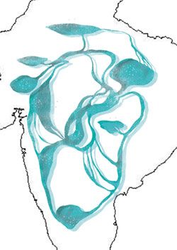 When the work is finished the water network will be twice the length of the Nile, the world longest river, and it will be able to divert water from flood-prone areas to those vulnerable to drought.
But geologists and ecologists in India question the science behind the Inter Linking of Rivers (ILR) scheme. If it goes ahead it might lead to ecological disasters and coastal erosion that would threaten livelihoods and endanger wildlife.
Water network
Versions of the ILR scheme date back more than 60 years to the days of British rule in India. In its latest incarnation the plan is to link 14 rivers in north India and 16 in the western, central and southern parts of the country, creating a water network some 12,500 kilometres long.
The idea is to reduce droughts and floods and create 35 million hectares of arable land in the process, as well as the means to generate 34,000 megawatts of hydropower.
This project is backed by Narendra Modi, who became the country’s prime minister in 2014.
Since then India’s National Water Development Agency has completed detailed project reports for three key initial river links – the pilot link between Ken and Betwa rivers in northern and central India; Daman Ganga and Pinjal rivers in western India; and Par and Tapti rivers in western and central India. A feasibility report of a fourth link between three Himalayan rivers – Manas, Teesta and Ganges – is in the final stages of preparation.
But many researchers question the science behind the scheme. They say there isn’t a simple division between river basins that carry too little and too much water – and that climate change has triggered changes in rainfall patterns with unpredictable knock-on effects on water flow.
They argue that it would be unwise to set in stone a vast new canal network at a time of dramatic environmental change.
Changing climate
A study published in July builds on this. Climate modelling once predicted that India’s dry areas will become drier and its wet areas wetter, but this is no longer the case.
A team of scientists from the Indian Institute of Technology in Bombay and Madras found a significant decrease in the monsoon rainfall over major water surplus river basins in India. The team’s computer simulations showed that the water yield in surplus river basins is decreasing but it is increasing in deficit basins.
”What may appear as water deficient today may become water surplus in the future due to climate change,” says study author Sachin Gunthe at Indian Institute of Technology, Madras. “So, how do you justify inter-linking?”
Geologists are concerned, too. Over the millennia India’s landscape has gradually evolved with the natural flow of water. “Most rivers are fed by monsoon rains and have built large floodplains and deltas over the years,” says Vedharaman Rajamani at the Jawaharlal Nehru University in New Delhi. “Pushing rivers around through ILR disrupts the supply of sediments and nutrients downstream.”
This could negatively affect agriculture, as farmlands have been built over centuries in floodplains and near river deltas. “Rivers recharge aquifers near farmland,” Rajamani says. “Besides, rivers are critical to freshwater biodiversity, including fish, and carry nutrients to marine life.”
Good side of floods
What’s more, a central target of the ILR scheme – to make flooding in some parts of India a thing of the past – ignores the very real value of flooding. For one thing, it carries huge volumes of silt that can reduce coastal erosion.
“A river is not just a natural pipe through which water flows,” says geologist Chittenipattu Rajendran at the Jawaharlal Nehru Centre for Advanced Scientific Research, Bangalore. “It carries deposits and sediments. Dams trap sediments that are critical to habitats downstream.”
Natural flooding also helps recharge supplies of freshwater below India’s floodplains and deltas. Without that sporadic influx from floods, salt water gradually intrudes into groundwater supplies in land. “Desiccation and desertification follow,” says Rajamani. Decreased sedimentation also leads to coastal erosion, he adds.
Rajamani says the presence of excess fresh water in the Bay of Bengal delta is especially crucial, as it helps create and maintain a layer of low salinity in the bay, which is one of the several complex, interlinked factors that influence the onset of the Indian summer monsoon. Artificially manipulating the natural system could disrupt the monsoon rainfall in the region, he says.
Rajendran says that the huge amount of water in dams would increase the water pressure in the cracks and push on crust below, possibly increasing the risk of earthquakes in the already quake-prone Himalayas.
Source: New Scientist
Attached link
http://www.youtube.com/embed/kmkvOpuQpXwMedia
Taxonomy
- River Studies
- Ecosystem Management
- River Engineering
- River Widening
- River Engineering
- Ecosystem
- India
1 Comment
-
1. In the 20th century India was an agricultural country with livable facilities mostly based on agriculture production with economic growth. In order to increase economic growth (GDP) it was felt that linking of rivers may give us more growth besides some growth through industries, and trade. Since the 90s the liberlisation of economic activity encouraged information technology (IT), mining, industries and other services. Now, the development in the 21st century has changed to services contributing to GDP upto 50-60% and industry about 25% and contribution of agriculture has come down to 15% in the last 2 to 3 decades.
2. Now, we have to think of economic growth in a different manner and priorities. The present population is 1250 million people which are likely to stabilise 1500-1600 million by 2050. Since the GDP growth will depend mostly on services, with land and water being limited to the present position and with more pollution. In the present century, priority should be given to skills, education and technology. This would require creating jobs in this sector with less use of land and water for urbanisation, energy, transport of various kinds and improving socio-economic conditions for the whole population with reduced in-equalities and also taking care of ecology and environment.
3. Since land and water have to be used together for creating new jobs, the proposed linking of rivers is not going to be helpful. The water already being used for irrigation and rainfed agriculture is already sufficient to produce 260 million tonnes of food. The ultimate requirement of about 350-400 million tonnes would be sufficient for the population in 2050 with improved agriculture technology and efficient use of water.
4. Water is available basically from precipitation with monsoon conditions available all over India passing through with various types and uses of soil and various products. The climate change studies show that intensity of precipitation with space variation may also change in the next 30 years. The last study with regard to precipitation and its various uses was done and published by the National Commission on Agriculture (NCA) in 1975. This shows the amount of water available in rivers as surface flow, ground water storage and surface storage in small tanks and various sizes of dams. It is necessary to do this study before deciding priorities for the use of water for various purposes. With the new technology and reduction of cost for desalination, fresh water can also be available specially along the sea coast and some rural areas.
5. The above reasoning gives enough idea that inter-linking of rivers is not going to be able to deal with the situation of floods and drought nor produce cheaper food and other means of rural development. The conversion of waste from agriculture, urbanisation and other activities in the rural areas can help by producing power, organic fertilizers and other products. This requires a different treatment of regulation and development of land and water for providing water and food security for the population of 1600 million by 2050 at much less cost and time.
6. Now cheaper means of electricity through waste conversion, solar energy, wind power would give better self reliance even upto the last village. Water harvesting on every piece of land and roof along with the better use of ground water storage created specially in forest areas should be done. The use of forest areas for commercial purposes and excessive use of chemical fertilizers in irrigated areas has also reduced the infiltration rate for ground water recharge.
It is suggested that the agency setup in 1980, namely National Water Development Agency under the Ministry of Water Resources be given the new task by making it a multi-disciplinary team. So that all conditions of land and water use and the actual requirements of the population can be considered at the same time, so that a balanced use of water and land with priorities for the next 30 years can be decided and monitored. Since all the states would have to be considered and there is competition between states and various stake holders, it may be better to locate it under the NITI Aayog.1 Comment reply
-
Надо разобраться с причинами и следствиями. Климат влияет на землю и воду или, наоборот, вода и почва воздействуют на климат. Рост стихийных бедствий и изменение графиков, расписаний и мест выпадения осадков показывает, что изменился механизм атмосферных явлений. Все, что происходит в атмосфере связано с круговоротом воды. А круговорот воды зависит от испарений. С развитием цивилизации появились невиданные природе искусственные испарения от водохранилищ, пашни, мусорных и рудных полигонов, обезлесения, от технологических процессов. Объемы таких испарений, качество и скорость или время пребывания воды на земле начинают превосходить органические испарения от биоты. И это является главной причиной изменения климата. См. мою страницу.
-